top of page

Drone Deer Survey / Deer Herd Analysis
What is a Drone Deer Survey or Deer Herd Analysis?
PAS prides itself on providing the most professional drone deer survey in Alabama and the surrounding states. Trail cameras or camera surveys can be good but take a lot of time, money, and effort. Using a combination of thermal and RGB camera payloads on our drones nothing goes unnoticed. Our herd analysis will allow you to decide if you need more foodplots, need to cull more does, or maybe even if you should develop a spring into a watering hole. We can provide antler to antler less ratios and total population. Other services include GPS coordinates of any deer location and a KML for importing into your favorite hunting app (OnX or Hunt Stand). We can provide images of your trophy bucks as well. Finally, we will provide a confidence level of our survey based on sunlight, cover, amount of vegetation/trees, and percentage of fields on your property. This service not only enhances property owners and deer hunters knowledge, but has proven to be beneficial to rural realtors when listing and showcasing recreational properties.


Thermal View Used to Locate Wildlife
How does it work?
1 :
Obtain Property Boundaries from landowner to determine how many drones/pilots will be required.
2 :
Preprogram flight areas for each drone. Typically, we can fly about 3,000' - 4,000' from the takeoff/landing point. We decide how many times we will have to takeoff from different locations in order to cover the entire property quickly and accurately
3 :
Once we arrive onsite, we begin flying in a grid pattern utilizing the Thermal Camera from the drone. Once an object or animal is spotted, we swap to the RGB or Daytime camera that allows us to zoom in and see amazing details of the deer.
4 :
Once a deer is spotted, we drop a pin on its location and maneuver the drone in a way that allows us to capture the best angle to take pictures and videos of the deer.
5 :
Once all of the information has been captured onsite, we analyze the data and provide the customer with a report and web-based map.
Call us Today: (205) 394-6256
Thermal Camera

What does it look like from the Drone?
Locate them in the thermal view (left), then swap to the RGB or normal view (right) to see what it is. This is the same shot/location/drone.

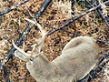
RGB Camera
Interactive Map Showing Deer Location During Survey
*Select the blue star, then the link under the "Attachment" to view image of Buck

Buck Summary

Herd Analysis Summary
Sample Deer Pics/Videos
*Note the clarity of the images from the Drone


bottom of page